
Back to Permits & Licensing Home
WHAT IS A SITE PLAN?
A site plan (AKA plot plan or survey) is an overhead drawing of the entire property, drawn to scale, and showing the location and dimensions of all property lines, any existing and proposed structures, and any proposed exterior work. This includes any buildings, structures, sidewalks, driveways, fences, pools, decks, patios, sheds, garages, exterior stairs, etc.
WHY IS A SITE PLAN REQUIRED?
Anytime a new structure or use is added to a property, an existing structure is re-built (such as fence, shed, garage, parking, addition, house, etc.), or a structure is demolished, an accurate site plan or professional survey is required to determine if the project meets the Ordinance requirements.
IS A PROFESSIONAL STAMPED PLAN REQUIRED?
It depends. New or reconstructed structures or impervious projects could trigger stormwater management or land development. Projects involving large stormwater permits or land development require stamped engineered drawings including a more detailed site plan. Small stormwater projects will require additional information on the site plan. Learn more about stormwater permits.
CAN AN EXISTING SURVEY BE USED?
Each application must have a new site plan/survey that includes all existing and proposed changes. It cannot be drawn on a previously approved stamped plan. It can be used as guidance for dimensions.
HOW DO I KNOW WHERE MY PROERTY LINES ARE LOCATED?
Refer to your property deed or use the Lancaster County Property Map to get a general idea of property lines (see link below). Boundary pins can sometimes be located using a metal detector. Fences and the public sidewalk are not necessarily installed on the property line and therefore cannot be used to determine where a property line is. If the applicant does not know where the property line is, then they will have to hire a licensed surveyor to determine the property line.
CAN THE APPLICANT DRAW THE SITE PLAN?
Yes, please use the following guidelines beginning on the next page for instructions of how to draw a site plan.
DIRECTIONS ON HOW TO DRAW A SITE PLAN
Step 1: Determine the property boundaries and lot dimensions before drawing a site plan. You can utilize the following tools if you do not already have information on the property. While the maps are not always accurate, they do provide dimensions based on recorded subdivision plans.
Use Lancaster County property map to find lot dimensions.
Step 2: Determine the location of structure and other site features in relation to the property boundaries before you draw a site plan. Using the property boundary location and dimension information gathered in Step 1, you must next determine the location of existing buildings, streets, tree location and tree canopy overhanging the site, and other site features in relation to the property boundaries. Measure the distance from these site features to the surrounding property lines. You can do this either with a tape measure, Google Earth’s measuring tool, or on the Lancaster County Tax Assessor’s maps.
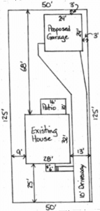
Step 3: Draw the site plan. Use all the information gathered in Steps 1 and 2 to prepare your site plan. You may draw your site plan by hand or use a computer graphics or drafting program. Most residential properties will fit on an 8 ½” x 11” piece of paper. Zoning cannot accept any plans on paper larger than 11” x 17”.
- At the top of the paper write the property address and property owner’s name
- Include all boundary lines and dimensions
- Label any roads
- Draw all existing & proposed buildings, driveways, gravel areas, stormwater BMPs, decks, pools, sidewalks, steps, etc.
- Direction of any existing and proposed stormwater discharge (e.g. with arrows)
- Approximate footprint and location of all structures on adjacent properties within 50 feet
- Label dimensions of all structures
Online Plan Submission
Online plan submission is now available for permit applications that require construction drawings/plans or a site plan. Use the link below to submit.
Directions
If your permit application requires construction drawings/plans or a site plan, follow the steps below to submit them online.
- Go to the CityView Plans Drop Portal.
- Create an account and verify your email address.
- Once logged in, select ‘+ New Project’.
- Select the jurisdiction ‘City of Lancaster, PA’ and fill in the basic project details. Then, click ‘continue’.
- Upload your plan(s). Then, click ‘continue’.
- Review your files for accuracy, and then click ‘submit’.